MUNICIPALITY OF ABADÍN
MANCOMUNIDADE
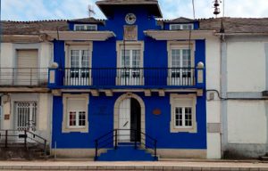
ABADÍN
The municipality of Abadín is one of the municipalities from A Terra Chá crossed by the North Way of St. James, with a path that runs along the hillside Pena da Roca up to A Xesta. There, the Lugar of Galgao is known for the shrine of San Cosme da Montaña, a place of worship where every September 27th a mass procession is held. On the façade you can see a shell that invites to turn left on a road that crosses the National-634 to reach Gontán, where the hostel for pilgrims and various services such as bars, pharmacy and a small supermarket are located.
There are several fairs held in the region. Gontán maintains two, the first and third Saturday of the month, in addition to large annual events such as Expogrelo or Feira de Santos. Half a kilometer from Gontán is Abadín, village which names the municipality that is the gateway to A Terra Chá. Legend has it that there was an abbot who collected the taxes in such a dictatorial way, that neighbors called him with breeching, ‘abadín’ or “little abbot”. This town will receive the walker with the church of Santa María, of Romanesque origin, which only requires a small detour to visit. Numerous examples of traditional architecture, stone crosses and chapels add to the attractions offered by Gontán and Abadín.


Take a walk

It is the shortest route of the network of trails of A Terra Chá with only 5.7 km that run through the inside of a “fraga” (forest), uniting in its route five water mills built along the river Fraga. It has a linear path that starts in the Lugar da Laxe, next to the restored Corvite mill. In this stretch the path runs parallel to the Anllo river, covered by a riparian forest. Then it crosses the road and runs along an old wagon road that serviced the intense activity developed in this small river

Ruta PR-G 152 - Ruta dos Muiños
- Duration – 1-2 Hours
- Length – 5,7 Km.
- Difficulty – Medium
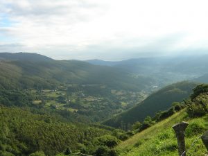
We enter A Terra Chá, a region from Lugo which, as its Galician name suggests, is characterized by a packed flat grassland path. We leave Abadín next to the post office and continue along a track, wide enough, to take a path that goes at right hand between oaks and crosses a wooden bridge. A short climb takes us back to a paved track with long straights that will alternate with some shadier paths up to Martiñán, where we cross the N-634. Later we pass Pontevella of Martiñán, the first of the bridges characteristic of the Terra Chá.
- Duration – 12-15 hours entire route
- Length – 22 Km.
- Difficulty – Medium
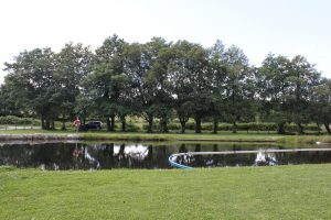
The Gontán recreational area is located on the banks of the river Labrada passing through the center of Gontán. It has a picnic area and a river beach equipped with an cement esplanade to facilitate bathing. It is framed in an environment of riparian vegetation, oaks, birches, alders and willows, among other trees.
- Duration – Spend the day
- Recreational area
- Restaurant Nearby
Information and Contact